MASTERARBEIT
2021Stadt und Land: Vergangenheit, Gegenwart und Zukunftsszenarien.
Analyse einer Beziehung anhand der Systemtheorie.
City and countryside: past, present and future scenarios. Analysis of a relationship based on systems theory.
Mentors: Prof. Sebastian Feucht and Prof: Pelin Celik.
PART I
The long-term sustainability of humanity and of the planet is inextricably linked to the fate of our cities. But the city is not an autonomous and self-sufficient entity: on the contrary, it is entirely dependent on the environment in which it arose, grew, and evolved over the millennia. Its own intrinsic capacity for growth and further development depends on the environment. In a historical period that calls many subjects into question, it is appropriate to reconsider the relationship between the city and the countryside. Using a concept apparatus borrowed from systems theory, this work has attempted to schematically reconstruct, from an unusual perspective, the past of European cities and their relationship with their surroundings: boundary, growth, equilibrium, centralization, decentralization, energy, information, and resource exchange are the key concepts, with which the city is described and analyzed as an entity that has grown and changed over the millennia. Systems theory and its key concepts have been used as an analytical tool, allowing a mapping of the processes that have changed the relationship between the city and its surrounding territories. Starting from the Neolithic period, the emergence, development and growth of the city as a spreading entity are reconstructed, highlighting its exchange and dependency relationship in terms of energy and resources with the land or natural territories. The resulting picture is a clear and systematic mapping of this relationship.The first part (DE) is available here.
MAPPING
The Senkey Diagram used to partially map the authors who analysed the relationship between city and country and their main issues approximately in the last 120 years.The full resolution image can be downloaded here.

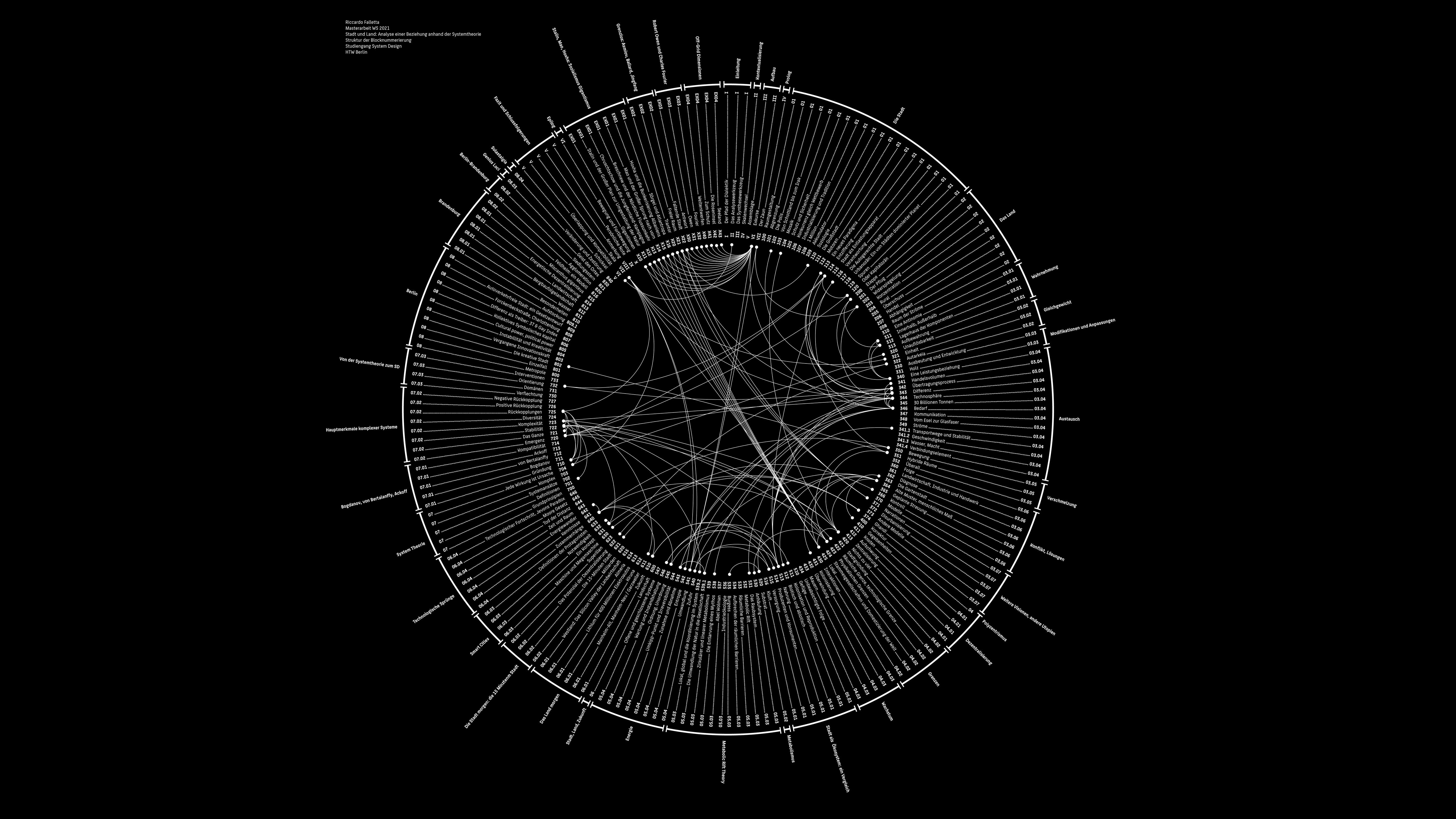
ASSEMBLAGE
The Arc Diagram used to map the topic and conceptual structure of the first part of the Master Thesis. The entire text is structured as an assemblage of interlinked concept blocks, each of which is assigned an ascending number. This numerical subdivision serves both to arrange the text more clearly and to connect different blocks within the overall text. The entire text is structured as a systemic assemblage of concept blocks. The full resolution image of the Arc Diagram can be downloaded here. The full resolution image of the Circle based diagram (Version 2) can be downloaded here.

PART II
The second part is the design part of the elaboration and focuses exclusively on the urban region Berlin-Brandenburg. In doing so, a synthesis is carried out on the basis of the collected findings and information of the previous part. Like other European metropolises, the Berlin-Brandenburg region is undergoing a period of profound change: located in the geographical and political center of Europe, it offers itself as a suitable place for generating new impulses, new stimuli and new ideas. In an era of profound change that affects all areas of human activity - from transportation to work, from education to the environment - old schemes and paradigms may be obsolete and may need to be replaced. The second part raises a variety of questions and issues that challenge those schemes and paradigms. However, these questions are not answered by developing a single concept, but by crafting narratives. This makes it possible to ask questions, raise doubts, and imagine alternatives. Narratives form an excellent tool to trigger discussions and provide the necessary material for the construction of speculative scenarios. Scenario building is the backbone of the second part of this elaboration: draft laws, trends, signals, environmental and territorial issues serve as a substrate for the development of the project. They are amplified and used as a framework within which several concepts have been built. The final form of the project is therefore a catalog of concepts, which is inscribed in the Brandenburg geographic discourse but can be potentially scaled and decontextualized. Some concepts are show an higher degree of feasibility and are currently in a further stage of development. Others present rather a pure speculative character. Yet all the concepts aim to provide a set of overall solutions for urban and rural contexts in the coming decades. The concepts are presented through the medium of comic. The nature, use and scope of individual projects are explained through dialogues.The second part (DE) is available here.
MAPPING
The Gigamap used to map as comprehensively as possible the main social, economical, energetical and natural characteristics of the region Brandenburg. By analyzing the specific characteristics of the districts, it was possible to highlight their discrepancies and similarities. The full resolution image can be downloaded here. 